Major Research Projects
Completed projects (after 2003)
Running projects
ANDRILL
Peruvian Andes
Formation and decay of peneplains in the central
Tibetan Plateau
Colloid-rock interaction
Fluctuating cementation intensities in clastic sedimentary
rocks
Tibetan Plateau Formation: tracing material flow around the
East-Himalayan syntaxis
How does/did the Tibetan Plateau grow? Geologic-geophysical
research in NE-Tibet
Link between frontal collision and the extrusion of the Tibetan
Plateau
SAHALL - Sedimentakkumulation auf den Halligen
Zukunft Hallig - Sedimentologische Untersuchungen auf den Halligen
Trace elements in rutile
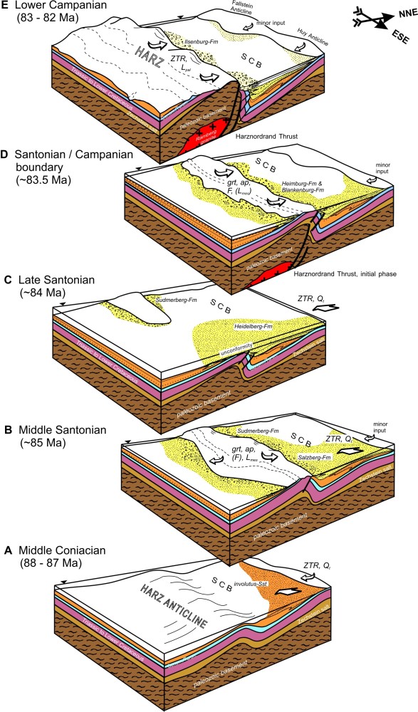
Inversion tectonics at the southern margin
of the North German Basin
The Cretaceous to Tertiary inversion tectonics in the North German Basin (NGB) constitute a significant problem related to the changing stress pattern in this huge area of subsidence and sediment accumulation since Late Paleozoic time. We currently focus on the southern margin of the NGB, and, specifically, on the example of the Harz Mountains and the adjacent Cretaceous Subherzynian Basin to the North. The interdisciplinary approach combines geophysical, structural, and geochronological data with detailed analysis of facies and sedimentary petrology of the syntectonic sediments. This allows for reconstruction and chronological calibration of the Late Cretaceous exhumation of the Harz Mountains and the contemporaneous basin formation and basin fill. The project is carried out in cooperation with the Institute of Geosciences at University of Jena.
Funded by: DFG 2006-2009 (Priority Programme SPP 1135)
ANDRILL - ANtarctic geological DRILLing
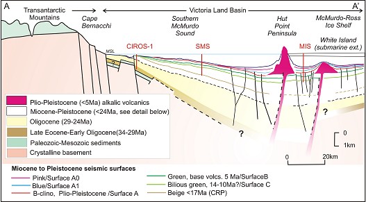
ANDRILL (http://www.andrill.org) is an international drilling project in the Ross Sea to unriddle antarctica´s Cenozoic climate history. At ANDRILL sites MIS (McMurdo Ice Shelf) and SMS (Southern McMurdo Sound) two >1000m sediment cores were drilled covering Early Miocene (~20 Ma) to Pleistocene strata of McMurdo Sound, Ross Sea, Antarctica. Sediments were deposited on the western flank of the Victoria Land Basin (VLB), a structural half-graben that forms part of the West Antarctic Rift system, and experienced subsidence since late Eocene times. On these cores we combine high-resolution on-ice measurement of chemical element concentrations using XRF core-scanner with off-ice high-precision chemical and sedimentological analysis on bulk samples (XRF, XRD, ICP-MS, biogenic components) and individual lithoclasts (LA-ICP-MS, electron microprobe, microscopy). The resulting multiple dataset will provide detailed information on sediment composition and contribute to several scientific objectives of ANDRILL such as the history of Ross/West Antarctic ice shelf expansion and retreat since ~20 m.y., sea-ice presence/absence in the McMurdo region, and the history of Neogene sediment provenance and accumulation rates in the VLB. Our major goal is to improve our understanding of the Neogene paleoenvironmental evolution of Antarctica with a special focus on the Mid-Miocene climatic optimum (~17-15 Ma) and the subsequent onset of major cooling (~14 Ma) along with the key question on the stability of cold-polar climate conditions during the last 14 m.y.
Funded by: DFG (SPP 1158)
“Antarktisforschung mit vergleichenden Untersuchungen in aktischen Eisgebieten”
Co-Applicant: G. Kuhn (AWI, Bremerhaven) (2006-2010)
Interpreted seismic section
showing wedge-shaped basin geometry of VLB and target strata of sites SMS and
MIS in relation to former CIROS-1 core (SMS Scientific Prospectus, Harwood et
al. 2005).
The Andes constitute the second largest orogen on earth. The steep western flank of the Central Andes in northern Chile and southern Peru is dominated by hyperarid climatic conditions since ~15Ma leading to extremely slow erosion despite high relief. Relations between source areas and sedimentary basins are well preserved, at least for the last 30 Ma. Our project aims at reconstructing uplift and differential erosion through time (Paleocene to Recent) and space (16°S to 22°S) based on petrological, geochemical and isotopic signatures of clastic sediments. Detailed chrono-strati-graphic calibration relies on precise Ar/Ar-geochronology of tuffs and ignimbrites as stratigraphic marker beds or valley fills. Detrital thermochronology will aid in constraining paleo-cooling in the source areas. Digital elevation models combined with field data from deeply incised valleys are used to estimate sediment volumes and erosion-accumulation rates. We are heading for a dynamic model of the Cenozoic evolution of the western Andean escarpment under changing tectonic and climatic conditions.
Funded by: DFG (2007-2010)
Co-Applicant (G. Wörner, GZG-Geochemistry)
Formation and decay of peneplains in the Tibetan Plateau
Large-scale peneplains constitute the most prominent geomorphic element of the Tibetan Plateau, however, owing to the poor sedimentary record, still little is known about their formation and the subsequent Cenozoic landscape evolution. The process of peneplanation was presumably related to a phase of intense erosion that followed nappe stacking and crustal thickening in the Late Cretaceous/Paleocene but preceded the main uplift of the Tibetan Plateau. By applying low-temperature chronology (fission track and (U-Th)/He dating), sedimentary provenance analysis, and cosmogenic nuclides we aim to (1) date this planation process in south-central Tibet, where well preserved peneplains were carved into granites and Cretaceous sediments, (2) reconstruct the paleogeography and geologic setting during post-orogenic erosion and basin formation by advanced provenance analysis of siliciclastic sediments, (3) quantify the Quaternary rate of erosion of the low-relief surfaces and the incision rate of rivers dissecting the peneplains using 10Be, and (4) evaluate whether the peneplains were covered by ice for significant periods in the Quaternary using a multiple nuclide approach (10Be, 26Al, 21Ne). Our study will lead to a much-improved picture for the timing and rate of peneplain formation and Quaternary landscape evolution.
Funded by: DFG, sub-project of Priority Programme (SPP 1372) “Tibetan Plateau: Formation - Climate - Ecosystems (TiP)” Co-Applicant: R. Hetzel, (Münster) (2008 - 2011)
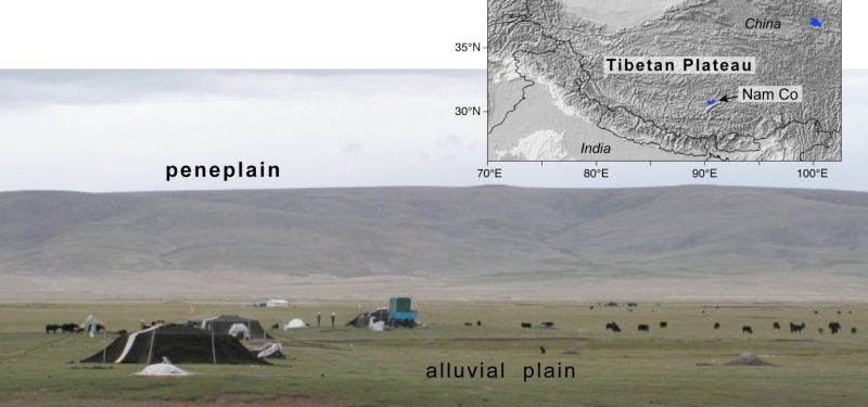
Well developed planation
surface above an alluvial plain north of the lake Nam Co.
More details: http://www.tip.uni-tuebingen.de/groups/group3.html
| Colloid-rock
interaction (Junior-Research Group / Nachwuchswissenschaftlergruppe)
funded by GEOTECHNOLOGIEN research program 2008-2011 (joint research program of DFG and BMBF) Scientific co-operations: Rice University, Houston; Institut für Nukleare Entsorgung am Forschungszentrum Karlsruhe |
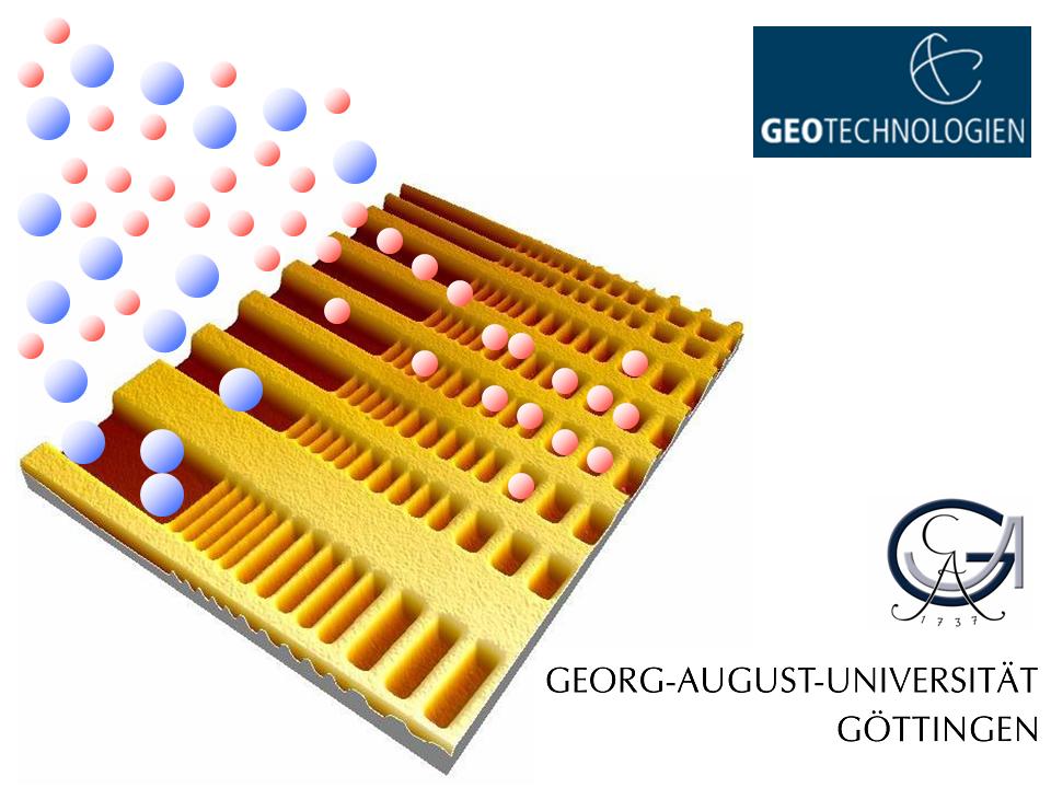 |
| Goal
of this project is a systematic approach to determine the interaction between
the mineral surface topography and colloidal particles. We will focus on
artificial surfaces with well-defined topography in the submicron range.
First experiments will focus on plastic surfaces and colloids to avoid chemical
and surface charge heterogeneities. As a second part, experiments are planned
with mineral precipitates of well-known topography and with several mineral
colloids. It is expected to improve the understanding of colloidal retention
in the environment as a function of macroporous surface topography of minerals
and rocks. Because colloids are ubiquitous in natural fluids, a broad field
of engineering applications exists for the expected results of this study.
Implications for contaminant transport and waste management are important
examples.
More details: http://www.sediment.uni-goettingen.de/surface/index.html |
| Fluctuating cementation intensities in clastic sedimentary rocks and the impact of sedimentary bounding surfaces on diagenesis |
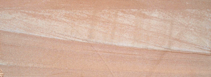 |
| Highly-cemented sandstones, which are associated with sedimentary bounding surfaces, may act as baffles for fluid flow. We focus also on investigations about intense cementation that may result in a pattern of oriented, highly cemented bodies within a sandstone section. We combine petrographical methods with thermochronological and geochronological methods to get information about geochemical constraints during the diagenetic history. The potential results about frequency and distribution of highly-cemented volumes could have a broad application in the prediction of reservoir sandstone partitioning due to cementation processes. |
Tibetan Plateau Formation: tracing material flow around the East-Himalayan syntaxis
The India-Asia collision is the Earth's most spectacular "natural laboratory" to study the geodynamic evolution of continental collision. The project deals with the link between frontal collision by the Indian indenter and the extrusion of the Tibetan Plateau. In the western part of the Himalaya oroclinal bending is well reflected by palaeomagnetic data. In contrast, data from the central part and a first result from the eastern part (Bhutan) indicate palaeomagnetic rotations, which are not compatible with an oroclinal bending model. It can be hypothesised that eastward extrusion of the Tibetan Plateau left its fingerprint in a long-term deformation of the Himalayan region forming a shear zone with strong clockwise block rotations and sinistral strike-slip faults between individual blocks. This model would match with present-day movements shown by GPS velocities. The proposed project aims at testing the hypothesis of a shear zone by analysing palaeomagnetic remanences in the eastern Tethyan Himalaya between ca. 83-89°E. West-east and south-north sections will be sampled to obtain a regional rotation pattern. Secondary pyrrhotite remanences will be used which proved to provide reliable results during former projects. Geological, geochronological and geothermometric work is involved in order to support the interpretation of the palaeomagnetic data. This multidisciplinary concept is based on a cooperation of scientists from Germany, Switzerland, Austria, Canada, China and Nepal.
Funded by: DFG - sub-project of Priority Programme (SPP 1372) “Tibetan Plateau: Formation - Climate - Ecosystems (TiP)” Applicants: E. Appel, L. Ratschbacher, M. R. Handy. P. J. O' Brien, I. Dunkl, R. Bousquet, R. Gloaguen, M. Konrad-Schmolke, R. Oberhänsli, J. Pfänder, W. Siebel
More details: http://www.tip.uni-tuebingen.de/groups/group13.html
How does/did the Tibetan Plateau grow? Geologic-geophysical research in NE-Tibet
The India-Asia continent-continent collision is responsible for the highest mountain range (Himalaya) and the largest plateau (Pamir-Tibet) on Earth and deforms large regions of Central and Eastern Asia (e.g. Tien Shan). The NE part of the plateau is the archetype for studies of active collisional tectonics, crustal thickening, and lateral extrusion along large-scale fault/shear zones (e.g. Kunlun, Altyn Tagh); these zones accommodated Recent Ms <8.1 earthquakes. Surface uplift of the plateau as a response to crustal thickening influences the climate of Eurasia. Combining geologic-tectonic-thermochronologic and active and passive seismic observation tools, we will elucidate in detail the structure of the crust and upper mantle in NE-Tibet. Our aim is to evaluate along which of the large-scale deformation zones crustal thickening was/is accomplished, whether active intra-continental subduction occurs along the pre-existing sutures in NE-Tibet, and whether lower crustal flow is a significant thickening and uplift mechanism for the plateau. The project will be executed in close cooperation with US and Chinese scientists. Integrating other geophysical (e.g. US magnetotellurics) and geologic investigations, our work will push ahead the overall understanding of collisional tectonics.
Funded by: DFG - INDEPTH IV (INternational DEep Profiling of Tibet and the Himalayas IV) Principal applicant: L. Ratschbacher (Freiberg)
Link between frontal collision and the extrusion of the Tibetan Plateau
The India-Asia collision is the Earth's most spectacular "natural laboratory" to study the geodynamic evolution of continental collision. The project deals with the link between frontal collision by the Indian indenter and the extrusion of the Tibetan Plateau. In the western part of the Himalaya oroclinal bending is well reflected by palaeomagnetic data. In contrast, data from the central part and a first result from the eastern part (Bhutan) indicate palaeomagnetic rotations, which are not compatible with an oroclinal bending model. It can be hypothesised that eastward extrusion of the Tibetan Plateau left its fingerprint in a long-term deformation of the Himalayan region forming a shear zone with strong clockwise block rotations and sinistral strike-slip faults between individual blocks. This model would match with present-day movements shown by GPS velocities. The proposed project aims at testing the hypothesis of a shear zone by analysing palaeomagnetic remanences in the eastern Tethyan Himalaya between ca. 83-89°E. West-east and south-north sections will be sampled to obtain a regional rotation pattern. Secondary pyrrhotite remanences will be used which proved to provide reliable results during former projects. Geological, geochronological and geothermometric work is involved in order to support the interpretation of the palaeomagnetic data. This multidisciplinary concept is based on a cooperation of scientists from Germany, Switzerland, Austria, Canada, China and Nepal.
Funded by: DFG - Principal applicant: E. Appel (Tübingen)
SAHALL - Sedimentakkumulation auf den Halligen
Vor dem Hintergrund eines global ansteigenden Meeresspiegels stellt sich die Frage, wie Schutzmaßnahmen auf den Nordfriesischen Halligen zukünftig gestaltet werden müssen, um Menschenleben und Sachwerte effektiv und nachhaltig vor den Gefahren, die durch zunehmend höher auflaufende Sturmfluten drohen, zu schützen. Die regelmäßig auftretenden Überflutungen („Land unter"), die in Abhängigkeit der jeweiligen Uferschutzbauten in unterschiedlicher Häufigkeit auftreten, hinterlassen auf den Halligen nach dem Ablaufen des Hochwassers Sedimente. Dieser natürliche Prozess lässt die Halligoberfläche langsam in die Höhe wachsen und bietet somit ein natürliches Pendant zum Meeresspiegelsanstieg. Ziel des Projektes ist zum einen die Bestimmung und das Monitoring der natürlichen Sedimentakkumulation auf den Halligen auf unterschiedlichen Zeitskalen, zum anderen Entwicklung und Erprobung geeigneter Massnahmen zur Förderung des Sedimentaufwuchses.
Gefördert durch: MLUR Schleswig-Holstein (2007-2012)
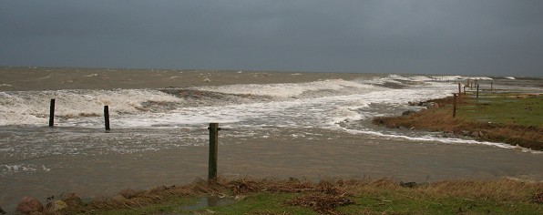
Suspensionsreiches Wasser schlägt über den Norddeich von Hallig Hooge (Sturmtief „Lancelot" 20.01.2007). Foto: M. Deicke
Zukunft Hallig - Sedimentologische Untersuchungen auf den Halligen
Im Rahmes des von der Universität Siegen, Forschungsinstitut Wasser und Umwelt (fwu), koordinierten Verbundvorhabens "Zukunft Hallig" wird das Teilprojekt ZukunftHallig D "Sedimentologische Untersuchungen auf den Halligen" durchgeführt. Im Teilprojekt D werden die Zusammenhänge zwischen Meerespiegeländerungen, Überflutungshäufigkeiten und Änderungen der topograpischen Höhe von Land- und Wattflächen durch Erosions- und Sedimentationsprozesse untersucht. Hierbei werden flächendeckend Sedimentationsraten auf den Halligen Hooge, Langeness und Nordstrandischmoor sowie in ausgewählten Arealen der Ostfriesischen Inseln Juist und Norderney bestimmt. Für die Quantifizierung der während eines Winterhalbjahres abgelagerten Sedimentmengen werden verschiedene Sedimentfallen benutzt. Zur Messung der mittleren Sedimentationsrate der jüngeren Vergangenheit werden an Flachbohrungen 137 Cs und 210 Pb Datierungen durchgeführt. Weiterhin werden vom LKN-SH topograpische Höhenmodelle der untersuchten Regionen auf der Grundlage von LIDAR Daten bereitgestellt. Diese dienen als Grundlage für GIS-gestützte Überflutungssimulationen. Prozessstudien an ausgewählten Halligstandorten dienen der Klärung der Frage wie Sedimente während einer Sturmflut auf die Hallig transportiert werden und von welchen äußeren Faktoren Menge und Qualität der Sedimente abhängen. Auswertungen von regionalen Bohrungen hinsichtlich des Setzungspotentials der die Halligen unterlagernden Schichten runden das Untersuchungsprogramm ab.
Gefördert durch: BMBF (2010-2013), Kooperationspartner: Universität Siegen, RWTH Aachen, LKN-SH
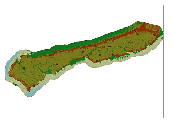
Digitales Geländemodell Hallig Langeness. Grundlage ATKIS® DGM1, ©LVermA-SH Bearbeiter: M. Schindler
Weitere Informationen: Forschungsinstitut Wasser und Umwelt, Universität Siegen
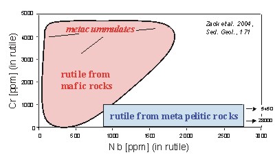
Rutile is among the most stable detrital minerals within the sedimentary cycle. It is well known that rutile may incorporate significant amounts of trace elements such as Cr, Zr, Nb, or Fe, that can be precisely quantified using state-of-the-art analytical equipment such as electron microprobe, laser-ablation ICP-MS, and ion microprobe. Recent studies have shown that the trace element content of rutile is strongly dependent on host rock chemistry and metamorphic grade. Consequently, detrital rutile may guide us to the petrology of its source rocks. Within this project, we first test our hypotheses in modern source-sediment systems of the European Alps, the Erzgebirge, the Central Andes, and Baja California. In a second phase the findings will be applied to fossil denudation-accumulation systems. The project is carried out in close cooperation with the Institute of Mineralogy at University of Heidelberg.
Funded by: DFG (2004 - 2006)
|
|
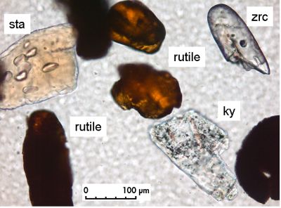
| Detrital rutile,
zircon, staurolite, and kyanite in heavy mineral separate from Upper Cretaceous
sandstone from Subhercynian Basin (Germany) |
Trace elements in rutile as petrogenetic indicator: Plot of Nb vs. Cr contents from different metamorphic environments. |